
GeoDecisions Wins TGIS Contract, Evolves U.S. Transportation Command IRRIS and EGIS Platforms
/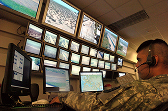
IRRIS identifies transportation scenarios to enable rapid deployment of assets, equipment, and personnel. TGIS will include IRRIS code combined with the EGIS map viewer.
(August 20, 2015/Harrisburg, Pa.) GeoDecisions was awarded a $17.7 million contract by the U.S. Transportation Command (USTRANSCOM) and the Military Surface Deployment and Distribution Command Transportation Engineering Agency (SDDCTEA) for the development and sustainment of the Transportation Geographic Information System (TGIS). This effort will evolve the award-winning IRRIS® application and Enterprise Geographic Information System (EGIS) through enhanced mapping capabilities and the ability to use the applications across multiple platforms. GeoDecisions, an information technology (IT) company specializing in enterprise geospatial solutions, will integrate IRRIS and EGIS functionality using the Esri® ArcGIS platform to create the new TGIS solution.
TGIS will enhance the ability of USTRANSCOM and its subordinate commands to manage infrastructure and assets, such as military cargo shipments, and to better share information worldwide. During daily operations or in an emergency, TGIS also will provide the Defense Transportation Tracking System and the Defense Courier Division with a command-and-control solution. Under the TGIS contract, GeoDecisions will reuse existing IRRIS and EGIS hardware and software and build an enterprise solution with greater global asset intelligence aimed to reduce costs, increase collaboration, and mitigate risks.
“We’re excited to continue our partnership with USTRANSCOM and SDDCTEA. For the past 16 years, we have supported the Command to revolutionize the use of geospatial technology within the Department of Defense to help enable our warfighters,” said Brendan J. Wesdock, MCP, GISP, GeoDecisions president based in Suffolk, Virginia. “TGIS is the next step in our technology evolution, and we look forward to continuing our Command partnership while transforming IRRIS and EGIS into a next-generation solution for greater visibility, tracking, and security.”
GeoDecisions’ experienced staff of professional consultants, analysts, and developers support clients worldwide. Fundamental to the company’s award-winning approach is the integration of spatial information to empower existing systems and processes. GeoDecisions’ philosophy is based on an enterprisewide approach to the integration of diverse information technologies, data formats, and systems. We are proud to be an Esri Gold-tier Business Partner and ISO 9001:2008 Certified.


