
GeoDecisions Helps PennDOT Handle 275 Million Traffic Records Per Month
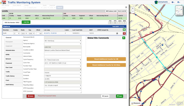
/(Harrisburg, Pa.) GeoDecisions, an information technology company specializing in geospatial solutions, developed a new traffic data system (TDS) that processes more than 275 million new records per month for the Pennsylvania Department of Transportation (PennDOT). Built on the Esri® platform, the TDS helps PennDOT’s Bureau of Planning and Research better manage the download of traffic data from collection sites throughout the commonwealth of Pennsylvania.
“Built to Federal Highway Administration standards, GeoDecisions’ redesign of our TDS provides us a method to seamlessly introduce new counting devices, more efficiently verify our raw traffic data, and speed up our process for creating yearly traffic volume maps,” said Andrea Bahoric, planning division manager with PennDOT.
The new TDS improves PennDOT supervision of 45,000 short-term or portable counters that classify vehicles, record traffic volume and weight, and determine driving speed. The system’s mobile Field Operations Module (FOM) also streamlines in-pavement counter inventory and maintenance activities.
“FOM enables PennDOT field technicians to use smartphones or tablets to perform site reviews and document issues,” said Greg Ulp, senior project manager with GeoDecisions. “Convenience and efficiency are critical factors when enhancing technology and managing assets.”
PennDOT’s predecessor traffic data management system contained nine applications with dated technology requiring manual intervention to collect and verify information. GeoDecisions’ TDS redesign features five modules streamlined for better performance and usability. The new automated system includes remote user access and cutting-edge geographic information system (GIS) mapping, web service, database, and coding technologies.
“Our transportation system solutions provide a proven business model for analytics, reporting, reliability, and technology workflow management, “said Tom Saltzer, vice president of government delivery with GeoDecisions. “PennDOT’s redesigned TDS is a long-term collection, verification, and geospatial solution that reflects their ongoing enterprise GIS investment strategy.”
GeoDecisions’ experienced staff of professional consultants, analysts, and developers support clients worldwide. Fundamental to the company’s award-winning approach is the integration of spatial information to empower existing systems and processes. GeoDecisions’ philosophy is based on an enterprisewide approach to the integration of diverse information technologies, data formats, and systems. We are proud to be an Esri Gold-tier Business Partner and ISO 9001:2008 Certified.


