
Machine Learning & GPS Help Memorialize Military Veterans
/Client: Department of Veterans Affairs (VA) National Cemetery Administration (NCA)
Location: United States
Initially Published: April 2020
Updated: March 2023

A team member is capturing all of the details of every monument and headstone. We hyperlink the photographs to the GPS features in the detailed geodatabase.
CHALLENGE
When the Department of Veterans Affairs (VA) National Cemetery Administration (NCA) wanted to ensure accuracy and data for veteran cemetery records, they turned to GeoDecisions. The NCA needed to verify burial record information to check for identity discrepancies, which required positional accuracy to the centimeter, photo documentation, and veteran data records validation. The project also created a solution that enables family, friends, and visitors to obtain locational data when paying respects at a VA cemetery.
SOLUTION
In partnership with OnPointe 3D Technologies, GeoDecisions used Trimble® R2 units and Robotic Total Stations (RTS) to collect data. To do this, our team:
Performed land surveys.
Conducted global positioning systems (GPS) data collection.
Took photographs of each headstone, flat marker, niche cover, monument, and cemetery infrastructure hardpoint (cannons, flagpoles, building corners, etc.).
Captured each grave's latitude, longitude, and elevation.
Migrated existing computer-aided design data to an NCA geodatabase.
Used Esri ArcGIS Collector to transfer the data from the field to the office.
Using the Feature Manipulation Engine (FME) platform, we translated and processed data into an NCA geodatabase model. This project updated data from 66 cemetery locations to give veterans’ families accurate geographic locations to visit their loved ones.
Transforming our Approach through Machine Learning
By using machine learning technologies—such as natural language processing (NLP) and optical character recognition (OCR)—GeoDecisions saved significant time.

By using machine learning, we took a task that, manually, would have taken two weeks and brought it down to as little as two hours.
To successfully use machine learning, we took an innovative approach to data collection. At the project's outset, we relied on a manual process to obtain tombstone information but found this incredibly time-consuming. GeoDecisions leveraged previous research and investments in developing a hybrid NLP/OCR machine learning approach to improve project costs, results, and accuracy and reduce human error. Through this innovation, we also used fewer manual quality assurance/quality control (QA/QC) measures and produced higher-quality results.
Machine learning also improved the physical data collection process. While in the field, our analysts developed formulas to automatically calculate the geographic information system (GIS) coordinates for tombstones and large structures, such as mausoleums. By recording the distance between markings, our machine-learning technology performed spatial analysis and formulated each asset’s location based on its distance from the original example.
We used Esri ArcGIS Online Basemaps and Esri ArcGIS Collector on mobile devices in the field to view pre-populated location points, expediting the photography process. Rather than manually loading the GIS data, our analysts selected each tombstone’s pre-populated point and added its asset information to the application. Our team also used Esri technology to query and color-code each grave marking, increasing efficiency and organization.
KEY TECHNOLOGY
Esri ArcGIS Pro
Esri ArcGIS Collector
Esri ArcGIS Online
Trimble® R2 Units
KEY RESULT
This effort resulted in a highly accurate geodatabase, which compared the information in the existing VA Burial Operations Support System database to confirm data accuracy or flag discrepancies. The largest of the 66 cemeteries was in Calverton, New York, which had more than 210,000 features. Other cemetery locations can be seen below.
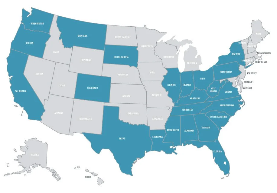
Cemetery locations included: Alabama, California, Colorado, Florida, Georgia, Illinois, Indiana, Kentucky, Louisiana, Mississippi, Montana, New York, North Carolina, Ohio, Oregon, Pennsylvania, South Carolina, South Dakota, Tennessee, Texas, Virginia, Washington, and West Virginia.


