
A Story Map Worth a Million Words
/An esteemed colleague of mine once posited that:
“If a Picture is Worth a Thousand Words...and…
A Map is Worth a Thousand Pictures...then…
A Map is Worth a Million Words”
How true that remains today as powerful and engaging story maps take us to places we may only dream of, recount tales of adventure from which we learn volumes, and help us discern answers to the complex challenges we face. Story maps fuse traditional cartography with textual content, images, video, and infographics for a more powerful knowledge transfer platform.
Communication Without Words
In ancient times, it was often not simply oral tradition, but a combination of oral tradition and artistic representation, that offered an effective communication platform to share information. Storytelling engaged and inspired in ways that other platforms could not, passing important knowledge from one generation to the next. However, humans have always relied heavily on visual input. As far back as the cave paintings of pre-historic man, graphic depictions of environment and experiences offered a means unique to our species to communicate ideas. Both storytelling and map-like graphics provided a vehicle to pass along not just data, but the knowledge and wisdom that people could then employ to improve their lives.
Even the earliest prehistoric evidence demonstrates that human culture relied heavily on both storytelling and map-like graphic depictions of their lives and environment to pass along important information.
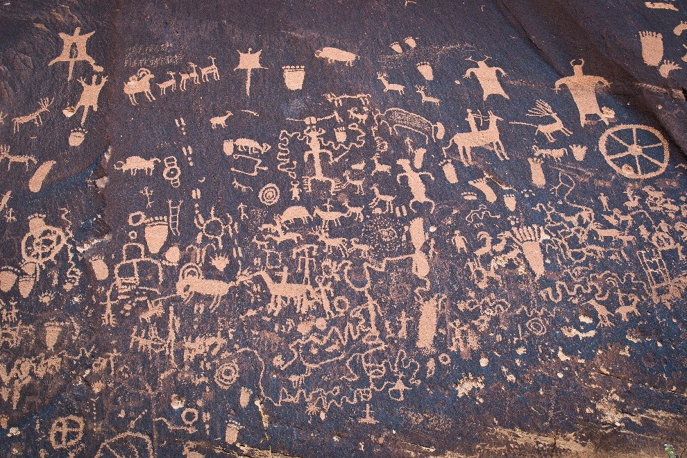
From the earliest pictographs, people actively recorded their surroundings using map-like drawings. By the 6th-5th Century BCE, early maps appeared, initially simply focusing on the spatial relationships between places. What is fascinating is how quickly maps began to depict far more than perceived spatial proximity between places. They began introducing topography and then many other types of features (e.g., small animals, castles, plant-life illustrations), telling stories to travelers traversing distances. These types of primitive story telling maps demonstrate how important visual communication mechanisms were to people and to the kingdoms and early forms of governments that employed them.
Staying Practical
Just like in the distant past, effective communication remains a critical aspect of today’s government and governing. Constituents and stakeholders representing both internal and external parties rely on government agencies to use accessible communication tools. These communication strategies provide insight into available government services, information, resources, and processes. Without effective communication strategies, government agencies fail at informing their stakeholders and citizens of valuable assistance the agencies may provide. This is why more and more governments are investing in spatial technologies to drive implementation of new communications platforms that leverage accessible and informative maps as a means of communicating and telling their story.
Telling stories through smart maps and infographics has proven to be an incredibly powerful and effective means of communicating even complex information. Government agencies have an opportunity to provide their constituents with more than a spreadsheet of complex and confusing data, or a traditional web mapping application publishing geospatial data. Instead, they can employ an engaging and inspiring storytelling platform that uses smart maps and infographics in a way that satisfies their agency’s core requirements.
Progressive government agencies do not wish to simply publish thematic data online, but to offer a stimulating and informative journey to their customers, a journey that shares knowledge. Methods used to narrate that journey include providing static maps for printing, as well as an interactive environment for self-driven exploration.

Complex custom solutions with significant custom code are difficult and costly to maintain.
An alternative to investing in a costly and cumbersome customized solution would be to adopt an easily configurable, off-the-shelf software platform that readily supports the majority of the agency’s requirements, yet provides an exceedingly flexible, dynamic communication platform with a much lower cost of ownership. The Esri® ArcGIS platform, and more specifically Portal for ArcGIS (the on-premise deployment of ArcGIS Online), configured by our knowledgeable team, provides just such an engaging and inspiring storytelling platform.
These configured story maps tell stories through journals, through time-series data, or through a user-driven tour of locations. They also provide a wide range of user tools to interact with the presented information in fascinating ways. And, best of all, they can be quickly and inexpensively configured for your needs.


Story maps present content via maps in combination with other forms of visual media.
This is the evolution of the story map from its earliest beginnings to the present. Story maps are worth volumes of words, since they allow users to explore and discern their own findings. They engage, inspire, and educate in ways that propel our culture and governance forward in new and exciting ways.
Visit https://storymaps.arcgis.com/en/ to find out more. Or contact us today.


