
A Single, Scalable Platform for ALL Your GIS Data – GIS Data Fabric™
/
Your organization, like so many others, is at a crossroads with data management. Like almost everyone else, you have created technology to deal with specific data and information needs, using available technology at a point in time throughout the years. You look at your information architecture with multiple applications, and the data is not easily shared or shared at all between applications or perhaps, between divisions. These silos will continue to prevent the elevation of new and paradigm-shifting insights. Now is the time to decide whether you stay on the path you are on, making more and more expensive fixes and modifications between disparate systems, or you shift your architecture entirely.
At the same time, the amount of data you have access to is growing exponentially. In a December 2020 Forbes article, the author noted that the amount of data created, captured, copied, and consumed worldwide increased from 1.2 trillion gigabytes to 59 trillion gigabytes, an almost 5,000% growth from 2010 to 2020. In a May 2020 report by the International Data Corporation, IDC, the amount of data created over the next three years will be more than the data created over the past 30 years; the growth forecast is a five-year compound annual growth rate (CAGR) of 26% which will continue through 2024.

Picking the Path to Exponential Growth
To get the most return on your data and prevent a continued patchwork approach, I recommend you consider the GIS Data Fabric™ path. GIS Data Fabric is a service-oriented architecture that sets out to minimize disruption by creating a highly adaptable data management environment that automatically adjusts to changing technology. More specifically, GIS Data Fabric is a set of data services that provide predictable, reliable, and authoritative capabilities across a choice of endpoints spanning on-premises and cloud environments to accelerate digital transformation. According to Esri®, a world leader in GIS software, 80% of all data contains location as a variable. We add GIS to the more common term of Data Fabric to capture the importance of location as a critical connecting factor between data.
Breaking It Down
GeoDecisions has helped customers develop this type of architecture for years. Now, we are developing the concept of GIS Data Fabric to help customers make that GIS digital transformation.
Let's break down the definition of GIS Data Fabric.
predictable, reliable, and authoritative capabilities – GIS data feeds or services that are always on, an attribute structure that is not changing, and official data vetted for errors. A service is a software that performs automated tasks, responds to hardware events, or listens for data requests from other software. An example includes Esri® REST services.
choice of endpoints - An organization may have multiple endpoints (URLs) to access data. This allows systems and processes to be autonomous. Bring these endpoints together using an Esri Open Data site.
on-premises and cloud environments – Your URLs may live in multiple places. For example, you may have Esri Portal for internal REST services and ArcGIS Online for publicly available data.
accelerate digital transformation – Building out a GIS Data Fabric will help bring your organizations' data together by exposing endpoints and bringing them together with an open data environment. An open data environment opens the organization up for more significant synergies and growth in how and where you use the data.
The Basic Pattern of a GIS Data Fabric
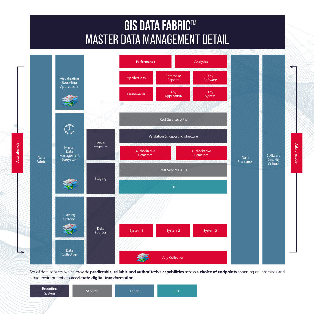
Now that we understand the definition better, let's identify the basic GIS Data Fabric pattern for an organization. The primary components include data collection, existing systems, master data management (MDM) ecosystem, and visualization and reporting applications. These are wrapped by data standards, software, security, and culture.
Software, standards, and security are logical components of your Data Fabric. Standards and software bring the geospatial data together. Security is essential for the Data Fabric to be trusted. But why culture? A successful GIS program needs to have dedicated leadership, provide training and a budget, and most importantly allow employees to take creative risks and think outside of the box. Using a maturity model like Slimgim can help outline culture, software, and data roadblocks.
GeoDecisions has your MDM covered. Our Platform as a Service, GeoQ, can be an important part of your MDM by supplying a fast, secure cloud-based data storage. GeoQ is a data collection, analytics, and dissemination platform which integrates seamlessly with Esri’s suite of products.
The GIS Data Fabric ecosystem uses services to exchange data between the different components of the pattern. This integration between the different MDM environments, provided by the services, is critical to your pattern's success.
The clock in the MDM block on the image represents the ability to store temporal data—the ability to look back and ahead in time. The whole pattern has arrows around the outside, indicating the GIS Data Fabric pattern's circular nature, rejuvenating and recycling data for the entire system and not just a single silo.
GIS Data Fabric Patterns for Transportation
There can be different patterns of a GIS Data Fabric. The pattern below is a detailed example of a department of transportation (DOT) GIS Data Fabric pattern. One big difference in this pattern is the use of a linear referencing system (LRS). This pattern uses Esri Roads & Highways for its LRS.
DOTs need to make sure their LRS is part of the fabric. Many times, LRS is only set up for HPMS and locked in a road inventory office. The data from the LRS can be used throughout the organization, leading to greater insight into asset management and other areas. The additional use of LRS geospatial data by implementing the GIS Data Fabric leads to a transformational change for a DOT.
It is important to keep systems away from the transactional LRS system and create a publication LRS environment in MDM where the data has already been through a quality check. This publication environment is a read-only area and allows for fast data access throughout your Data Fabric.
Using a Linear Referencing Method
All data relating to the road network should be referenced to the road network using one of the LRS Linear Referencing Methods (LRM). An LRM is simply a method of measurement along a network. In the DOT’s the most common LRMs are mile point (distance from the start of a route), reference posts (green posts along a road with reference numbers), coordinate route (a coordinate like a latitude/longitude and a route name attribute), or stationing (reference points that are placed along the horizontal measurement of a route centerline or a baseline at a regular interval).

Tips:
Use a maturity model like SlimGim to help identify the culture, software, and data roadblocks.
Agree upon enterprise data standards. Build out high-level guidelines and organizational data standards to guide the creation of your GIS Data Fabric.
Engage a consultant, like GeoDecisions, who understands your business processes and can lay out your GIS Data Fabric pattern to grow easily with your organization.
Consider using GeoQ as the foundation for your GIS Data Fabric.


